


The long ride home
- Jul 25, 2018
- 7 min read
By chance that Jason Miller was driving to Virginia and I had extra vacation around Labor Day, I took the opportunity for the one-way ride to Virginia. I ultimately went to visit a friend living in Lexington, VA then ride my bicycle home over the next 4.5 days. The immediate undoing of my shoot-from-the-hip plans was finding that I left my bivy sack back in Pittsburgh. Jason kindly lent me a tent fly so that I could still at least build a shelter each night - more on this later.

Day 0, Stokesville, VA to Lexington, VA: After camping out in Stokesville, VA to cheer on the Shenandoah Mountain 100 mile mountain bike race start, I saddled up for the 65-mile warmup day to Lexington. The numbered county roads line with fenced-in cows provided a serene, pastoral backdrop for almost 30 miles. I learned to coexist with the 35+ lbs of gear straddling the rear of my Redline Conquest Pro cyclocross bike. 25 miles in, I rested at Augusta Springs state park to eat and relax, watching families gather for Sunday chicken after church. Arriving at Goshen Pass, a veritable Ohiopyle in GW National Forest, the heat of the day receded to the pass’s cool air and summer weekend sensations of kids playing, feet refreshing in the Maury River, and cool valley breezes idling by. Incredibly settling, I napped on a cool riparian rock as hikers came and went. About 65 miles into the day, I fittingly rendezvoused with my friend and his family on Chessie Trail, the Lexington rail trail, which was a fine finale to the day. We spent the next two days eating (me: fattening up), hitting the gym, kayaking the Maury River, touring the Washington and Lee University campus, and catching up over a decade of missed camaraderie.


Day 1, Lexington, VA to Shenandoah NP, 85 miles: The only real plans I had for my trip were to ride along the Blue Ridge Parkway and Skyline Drive in Shenandoah NP, then improvisation with a paper map! My host insisted that I take the free ride up to the Parkway from his house, skipping about 2000 feet of elevation. I covered the northernmost 65 miles of the BRP, finishing on Skyline Drive for the last 20. Snake carcasses, perfectly built turns, and moments of cycling zen far outnumbered the cars. I chatted with two high schoolers about their low-budget cross country cycling trip as we crossed paths (takeaways: same gear, I had less BO, they are badass). Snacking under a tree, I waxed adventure with Appalachian Trail SOBOer Pippi, and gave her a much-needed water bottle to fend off dehydration. In the worst moment of humanity in the trip, a Harley rider flagrantly passed and tried to kick me off of my bike for no apparent reason - I’ve never wanted to imprint my SPD cleats on someone’s face so badly. A mama bear and several cubs crossing the road directly in front of me brought my mind back to the present, one additional bear is all I would see. Threatening skies made good on their tacit promise and sent me rifling for that tent fly, which I hastily flung over a mile marker post and waited out the storm with Ramen noodles. Getting late, I found an AT trailhead and I surreptitiously pushed my bike along it, scouting a great site to lay a ground cover down and create an unsealed tent with the fly and using a branch propped up in the Redline’s cranks to support the fly’s structure from it’s otherwise flaccid form. The first and most anxious day was over. The wettest day was next.


Day 2, Shenandoah NP, 65 miles: Three minutes into the ride, a northeast-oriented string of storms heading northeast parked itself over my route for the day, ensuring inescapable drenchedness. 5 miles in I found a picnic area to restock water and prepare breakfast. Finding both my lighter and Jetboil not lighting and water pumps turned off, I ate cold oats and retreated to a bathroom to repack and rewarm myself and rehydrate from the sink. An hour later I set off to do 30 more miles, pedaling to the rhythm to a peppy playlist to keep the spirits high and using focused diaphragmatic breathing to keep warm. I conjured up this mantra to keep steady progress: “The absence of comfort finds the surreptitious hideouts of raw bliss.” True as that is, a long descent left me so thoroughly chilled that I conceded to a bathroom facility, locked the door, and proceeded to bathe in the hand blower’s invisibly warm stream of life, drying off each piece of me and my clothing, and reinvigorate the body. Two full hours later, I remounted, immediately climbed 1000 feet, and finished off the wet day again camped out near a trail. After setting up my shelter in the rain, and proudly hanging wet clothes to dry inside, I fell getting out to pee and accidentally took the main support down with me, pitifully taking the structure down, adding some rainwater to my sleeping bag and ground cover. Low lows always seem to precede the high highs.


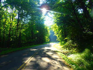
Day 3, Shenandoah NP to Cumberland, MD, 100 miles: Waking up to crepuscular rays of light drawn by the canopy maze gave me an overwhelming relief for a dry, warm day ahead. I used a visitor center to lay out some items to dry, restock water, and make a warm oat breakfast. The 5 mile descent to Front Royal was biting cold in the wind, but the elevation loss provided a quick rewarming. The roadsides of this area of Virginia were unattractively treated as public garbage receptacles, and although the roads were tight, drivers were respectful of my presence. A long, steep climb wholly convinced me to lower my chainring gear ratios in the future - extended stretches of standing and mashing burned my finite supply of energy matches quickly, finally extinguishing upon reaching the windy ridge. Vehicles whizzed by, with fleeting curiosity about the vagabond heating up a Mountain House with intent focus on the side of the road. A fun descent led to undulating, open valley roads. My printed map didn’t resolve a left turn that I missed, which serendipitously put me at a farmer’s market stand, a natural place to restock and breathe fresh air. The farmers gave me backroads directions to get back on track towards Cumberland, including several miles of beautiful new asphalt ribbons played over and over like a pastoral zoetrope. Several false flat climbs along source streams led me into Paw Paw, Maryland, at the southern entrance to the famous C&O Canal Path Paw Paw tunnel. Knowing free hiker/biker campsites lay along the trail every few miles, I pressed on along the C&O until I dusk receded to dark. An empty campsite (they all were) with perfectly set trees called me to it, affording use of the guide wires to open up the space into what felt like a well-deserved tent-palace. Sleep came easily. This was a high high.


Day 4, Cumberland, MD to Connellsville, PA, 90 miles: And not primarily via the C&O or GAP, like one would think and is easiest. The resetting sleep and beautiful sunrise with oats at the site picnic table hid the fact that my left Achilles was beginning to show signs of tendinitis and my right shin felt “splinty”, both afflictions I’ve had before from cycling and running. I pedaled gingerly all day, preferring the slow cadence of climbs to the coaxing speed of the flats, and resting on the downhills. I also moved my cleats forward ⅛” to induce less flexion in my legs, hoping that would stave off ride-ending states of those injuries. In Cumberland, a shop cyclist recognized my kit and chatted me up about the splendid riding in the area, which I promptly experienced after taking his suggested route to Frostburg on a few state roads that climbed 2000 feet steadily through Mt. Savage to Cumberland Gap, imperceptibly steepening their course. US Route 40 took me from Frostburg to near Uniontown, which was a bittersweet route of punchy, extended climbs, incredible scenery, and passing my family camp, certainly pivotal in developing my love of the outdoors in the formative years. Also, lots of tractor trailer traffic juxtaposed from pastoral scenes and butterflies aimlessly fluttering through my front wheel many times pushed and pulled me from wanting to stay on this route. Entering PA, all hell broke loose. Immediately the drivers became less concerned about my safety, and of course it started raining on and off, the worst kind when cycling. Realizing that Connellsville, my stretch goal for the day, was still rather far, I deferred to Google Maps for a reroute, which seemed promising as it slowly descended the western ridge of the highlands. Glad to have a cyclocross bike right then, it put me into the dirt and gravel roads of the state game lands close to the Lost Crag. The only time I stopped to push my bike on the trip was on a 20 foot uphill that was so gravelly that it was akin to walking in quicksand. An enjoyable dusk descent along a stream followed by a few short miles into town put me at the free GAP trail Adirondack shelters. Having the best conditions for a night’s sleep was not to be, as this Friday night the townies decided to drink and be loud in adjacent shelters. Uncaring, I shooed them away each time, fighting for my much-needed sleep. Which didn’t happen.


Day 5, Connellsville, PA to Baldwin, PA, 55 miles:
With little sleep, and injuries getting worse, my ambitious plans to ride roads back home were not to be. Not to take away from what others experience, but the flat, repetitive miles along the rail trails is every bit as enjoyable as mowing the lawn. I started early and reluctantly rode the GAP back to McKeesport, fighting every pedal stroke to ensure that injuries didn’t pass a need-to-call-for-a-ride-home threshold. Happy to watch the miles tick by and think of what lay ahead when I get home kept my spirits high. A car cruise and festival in Glassport was a morale boost. 10 miles from home, almost there. 5 miles from home, shooting pain in my Achilles almost left me in a pile of human and bike on New England Road approaching Century III mall. I egregiously pedaled in a compensatory mode until I reached my neighborhood. Drifting down my street, I likely appeared mad as I fist bumped the air and hollered to nobody that I was finally done! I cranked up some country tunes, put the bike away, and savored one of my most deserved shower beers ever.


Rough Totals:
$26 spent ($10 to enter SNP, $3 matches, $7 Nuun tablets, $6 fresh roadside veggies)
~450 miles including the warm up day (each ride segment was recorded with a Garmin 310XT GPS unit, uploaded here: https://www.strava.com/athletes/147165)
~30,000 feet of climbing (eff you US route 40!)
~30,000 calories burned
~38 hours pedaling
Only ~50% of phone battery used, mostly to text and check routes against Google Maps
~3 hours writing in my journal to record this trip in fine detail, which helped to document this months later
One lonely, unused bivy sack
Comments